


|
RCBJ-Audible (Listen For Free)
 |
Residents Are Demanding a “Positive SEQRA Declaration” From Town Planning Board To Study A Host Of Potential Harms
By Tina Traster
With numerous environmental concerns in question, including negative impact to wildlife and biodiversity, the presence of the bald eagle, disruption to an historic walking trail and a threat to core forest at a time when climate change is a pressing concern, a proposal by the Islamic Center of Rockland (ICR) to build more than 30,000 square feet and add more than 200 parking spots in one of Clarkstown’s remaining mountaintop conservation zones clearly calls for deep environmental study – or more technically a “positive SEQRA declaration.”
But whether the Clarkstown Planning Board agrees to truly have this site studied objectively by external experts, and not just rely on the applicant’s findings, as is often the case, remains to be seen.
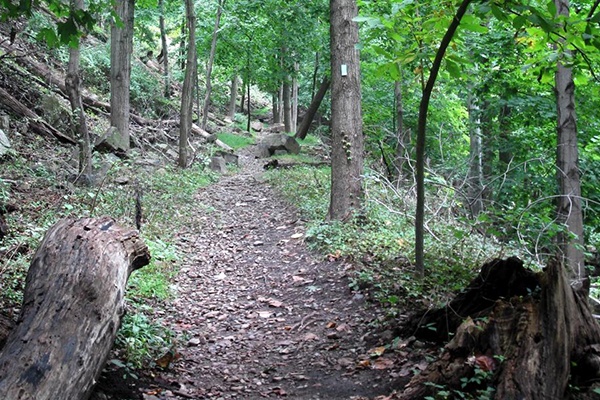
In a packed house on Wednesday at the Planning Board’s first public hearing on the proposed project, mosque congregants, who came early and packed the heart of the chamber, made pleas for why the house of worship needs more space for a gymnasium and meeting rooms. At the same time, residents from Mountainview Avenue, Christian Herald, Central Nyack, and Clarkstown at large unanimously spoke up against siting an enormous development that will disturb nearly seven acres of a sensitive ecology at the highest elevation along Mountainview Avenue. Those addressing environmental and traffic safety concerns, including residents who’d sent in a stack of letters to the Planning Board in advance, outlined worries over increased traffic on the dangerous serpentine two-lane road, additional flooding on a road already challenged with constant runoff, sheeting rain, ice, noise and light pollution, loss of habitat, and obstruction to the viewshed, and interference with the Long Path, an historic trail that runs from the GW Bridge to the Adirondacks.
“I walk this path. There are eagles all around. Many birds – more than 60 species. This is a corridor for many animals.”
By definition, a SEQRA (State Environmental Quality Act Review) analysis must include the cumulative and community impacts of allowing a particular development – even as the planning board weighs the application of a house of worship to expand.
“This portion of land between Christian Herald and Route 59 is a narrow corridor,” said Eric Larsen, a member of the New York/New Jersey Trail Conference and a member of the Palisades Parks Conservancy. “I walk this path. There are eagles all around. Many birds – more than 60 species. This is a corridor for many animals.”
The applicant claims there are no eagles or birds in this flyway, but several residents testified about the presence of eagles, owls and other wildlife.
Larsen also pointed out that when the mosque’s new structure is built, “it will destroy the profile,” of the trail’s viewshed.
The Islamic Center of Rockland (ICR) built the mosque two decades ago on land zoned for conservation, known as R-160 in the town code. In its letter to the Planning Board, the Rockland County Department of Planning reminds the board that “the R-160 zoning district was established as a conservation district to preserve the town’s scenic resources, including preservation of steep slopes and the prevention of loss of forest cover.”
Town of Clarkstown Established R-160 Zone To Protect Town’s Scenic Resources
The town established the R-160 zone 40 years ago to protect the town’s scenic resources such as wooded areas, steep slopes, open spaces, and scenic vistas.
The County Planning Board letter also says: “oversized structures and increased impervious surface area will result in the degradation of the steep slopes and forested area found on the site.”
While mosque congregants and a pair of synagogue representatives made the case that the mosque has been a good neighbor, opening its arms and offering charity to those in need, residents living along the road expressed deep anger at the mosque for removing a “football field” swath of trees atop the mountain sometime before 2017, and using dirty fill to construct an ad hoc parking lot. At the time, residents along the road blew the whistle, and the town agreed in a Civil Compromise dated May 2018 to allow the ICR to simply pay a $5,000 fine. The ICR never had a permit to remove the trees or bring in fill, nor does it have a permit to continue parking on the bald, scorched land that has continued for the past five years without any town code enforcement.
Residents along the road expressed resounding anger over the ICR’s disregard of their own land stewardship – and told the planning board that this is yet another urgent reason for deeper environmental review of the project, namely a positive SEQRA declaration.
“In this time of climate crisis, schools, community centers, private residents and businesses should all minimize development and use as much of their land as possible to support local natural habitat,” said Christine Toth, a Mountainview Avenue condo owner. “Places of worship should certainly follow suit.”

Through its landowner the Rockland Muslim Trust, Inc., the mosque is proposing to expand its 10,000 square-foot facility into a far more extensive compound by adding a 1,750 square-foot addition and constructing a two-story, 32-foot high, 29,200 square- foot, masonry building dug into the mountainside. Adjacent to this new superstructure are plans for a 17,500 square foot “recreation area” and next to that, parking for more than 200 cars.
Merit Of Application Will Truly Be Tested At Zoning Board of Appeals
And while the Town Planning Board must decide whether to impose a strict environmental review and preserve the character and the integrity of the R-160 Zone, the merit of the application will ultimately be decided at the town’s Zoning Board of Appeals, because the applicant needs several variances, including a “use variance,” that will test the teeth of a law Clarkstown passed in 2016 that restricts non-residential development on town roads.
The impetus for adopting the local town law emanated from goals set in the updated Comprehensive Town Plan. These goals include preserving the suburban and remaining semi-rural character of the town, developing zoning and building regulations that reduce or restrict odors, sounds, commercial traffic, light pollution and other negative environmental impacts on residential areas, and expanding initiatives to safeguard neighborhoods from inappropriately scaled development.
The entirety of ICR’s mountaintop property is in the R-160 District.
The applicant’s attorney Frank Phillips on Wednesday stated the applicant needed “minor variances” – a clear understatement. In the County’s Department of Planning letter to the town’s planning board, it states “The building coverage and lot coverage are 236 percent and 440 percent respectively greater than the permitted maximum.” The letter goes on to say: “granting floor area ratio and building/lot coverage variances of great magnitude appear to directly contradict the goals of the R-160 zoning district.”
A variance will be required for Maximum Principal Building Coverage. Zoning in the R-160 Conservation Zone allows for 2.5 percent of a lot to be covered by the principal buildings; the ICR is asking for 8.4 percent coverage – more than three times the allowable coverage.
Variances will also be required for Maximum Lot Coverage, and for plans that impermissibly put parking lots into preservations easements.
A variance will be required for Floor Area Ratio (FAR), a calculation of the total building size compared to the lot size. The R-160 Conservation Zone allows for a FAR or .05; the ICR is asking for .12 – more than double the allowable size.
At the first public hearing on Wednesday, the Planning Board stepped gingerly around the applicant’s details — focusing as it usually does — on large, land-disruptive applications, on simply the traffic and viewshed. The ICR and the town’s traffic consultant AKRF stated that the additional traffic to the road will have no impact. As always, Board Member Phil Gaetano expressed his “mock” outrage over the so-called validity of the traffic studies, saying, “Forget about your report – it has no credibility.”
Traffic reports presented to the Planning Board typically say there will be no impact to local roads; and even though anecdotal evidence clearly contradicts these claims, the planning board usually resorts to saying, “we rely on our experts.”
What made a greater impact, however, was a video prepared by town residents who’ve organized to oppose the development showing nearly 100 cars snaking from the mosque’s driveway down Mountainview Avenue and backed up to the entrance to the Thruway – a regular occurrence every Friday when the mosque’s services conclude around 2 pm and at other times when services let out.
Planning Board member Edward Guardaro also asked the applicant whether traffic data compiled in the recent project of a 225,000 square-foot warehouse on Route 303 and another warehouse expansion further north on the state road, had been incorporated into the ICR’s traffic study.
It should be noted that the ICR’s traffic study was conducted at the tail end of the COVID pandemic – a time when many people had still not returned to the office, a resident pointed out.
Ultimately, Planning Board Chair Gil Heim told the applicant to broaden its traffic study and to conduct a “balloon test,” which shows the mosque’s visibility 360 degrees around.
There is precedent at the town planning board to protect R-160 land.
For years, the Blinn family, who live at 2 Old Stone Road in Valley Cottage, have tried unsuccessfully to subdivide a 27.7-acre lot to include three houses – two on the ridge line and one along Christian Herald Road, which intersects with Mountainview Avenue. The entire acreage sits in an R-160 zone. The Blinns have a right to develop their land but not in the cluster configuration they’ve proposed. The planning board has continuously expressed concern with the application that’s been pending since 2008 due to the proposed clearcutting of the forest ridge and the impact on the viewshed.