


|
RCBJ-Audible (Listen For Free)
 |
Orangetown Town Board Acceded To Property Owner’s Demand Enlarging Portion Of Property Eligible For Commercial Development
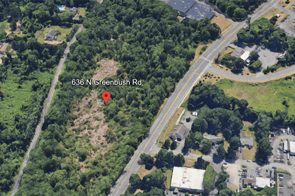
Is it the green line or the blue line? Or it is the red line – does anyone really know where the line should be? Everyone is confused, and what about the dinosaur footprints? Allowing a moment of humor, the serious business before the Orangetown Town Board last Tuesday twanged of a country song being workshopped. But at stake was whether clarification of a zoning line on a 17-acre parcel at 636 North Greenbush Road would allow a prospective developer to move forward to the town’s Planning Board with a proposal to build a self-storage facility against the wishes of North Greenbush Road neighbors.
The developer’s representatives, attorney Don Brenner and land surveyor Jay Greenwald aimed to explain that the Town’s current zoning map was too ambiguous to determine what portion of the parcel is commercially developable and what part is limited to residential use. They had a difficult time pinning down why the line they were advocating for was accurate as opposed to two other lines delineated on the map. The North Greenbush Road parcel spans two zones, with the larger portion in the R-40 (Large Lot Single Family) residential zone and the smaller part in the LO (Laboratory/Office) zone. The developer needed to maximize the portion in the LO zone to accommodate its plans for a 120,000-square-foot self storage facility. The 17-acre wooded parcel sits between North Greenbush Road and Route 303.
Several residents who packed into the Town Hall chambers raised objections to granting the developer the shift in the zone line, with Kelly Mariss calling it a Trojan Horse but ultimately the town board voted unanimously, with Deputy Supervisor Denis Troy’s urging, to grant the developer the zoning line shift.
“I don’t understand why you have to do this,” she said. “They bought it. It’s their problem. It’s not fair.”
Town resident Robert F. Zerilli, along with others, pointed out that the issue had not been property studied.
“I don’t think the studies are there,” he said, adding that another Orangetown warehouse will add noise, light pollution and trucks to Route 303.
At the close of the public hearing, Town Supervisor Teresa Kenny said she was inclined to deny the petition. She said the presentation was confusing, and it was not clear why the Board needed to act. Town Attorney Rob Magrino weighed in that the Board did not need to do anything – moving the line was a discretionary act, denial was unnecessary and would only trigger litigation. The town board, which pointed out repeatedly that it was not their task to determine the merits of the proposed project — that’s for the planning board — seemed at sea for much of the meeting. The Board then moved into Executive Session to discuss the matter privately with counsel. Deputy Town Supervisor Dennis Troy, an unelected town official, went into the Executive Session with the current Board.
The Board returned from Executive Session in less than 15 minutes, and Kenny signaled the town would approve the request, partially because the town was sued in a prior case over a zoning issue which cost the town and taxpayers money. In the 2018 case, Muhametaj vs. Town of Orangetown, town officials made representations regarding the zoning on a particular lot that a purchaser relied on but subsequently the town refused to approve a subdivision, backtracking on the representations it had made to the buyer. The buyer sued the town in Rockland County Supreme Court for damages and for declaratory relief on the zoning issue. After two years of litigation, the town settled with the buyer, paying him $575,000.
Kenny also said she knew “Jay”, the surveyor for a long time, and “if I can trust anyone’s assessment I can trust his.”
The town determined the line shift would not have any adverse environmental impact under SEQRA (the State Environmental Quality Review Act), issuing a “negative declaration.” There had been no discussion of environmental impact during the hearing.
Then the board voted unanimously to approve moving the line as the developer requested, clearing the way for a survey to be certified and a proposal for the self-storage facility submitted.
Rathmagurry Realty purchased the 17 acre parcel in 2016 from John Palladino for $850,000, according to records on file with Rockland County. The eastern side (accessible from North Greenbush) is zoned R-40. The western side (accessible from Route 303) is zoned LO. The problem, according to the developer was that nobody is certain where the zoning line demarcates the border between the two zones.
Three Lines On A Map
The developer’s surveyor said that recent changes in the Town’s Zoning Map made it difficult or impossible for him to certify a survey for submission to the town for plans to construct a 120,000 square foot self-storage facility on the LO portion of the land. A map presented to the Town, showed three possible demarcations.
The first, represented by a green line put the demarcation close to Route 303, which would make the parcel mostly in the R-40 zone and not give the developer enough acreage to build out the self-storage facility.
According to the developer, a second line, in red, showed a demarcation that was accepted by the Orangetown Planning Board in 2017 when it granted preliminary site plan approval for a residential subdivision that would have allowed the construction of 68 townhouse-style two-bedroom condominiums on 8 of the acres. The plan was abandoned during the application process.
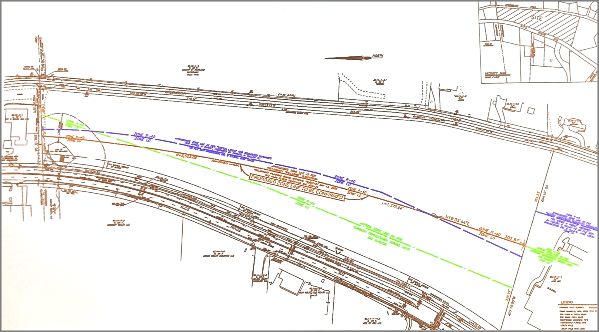
The third line, in blue, was very close to the red line, and represented a natural connection to the zoning line on the property to the south.
Either the red or blue line would provide the developer with enough property in the LO zone to allow it to certify a survey and file an application for approvals for the self-storage facility. It would also move the commercial facility much closer to the residences on North Greenbush Road.
The relocation of the zoning line is only the first step in a long process to secure approvals for a self-storage facility. The developer still must submit plans to the Town’s Planning and Zoning Boards and secure approvals and variances at each step.
Rockland County has experienced an eruption of self-storage facilities, including new construction and the conversion of existing buildings like West Rock Tennis Club in Clarkstown into Prime Storage and the former Macy’s site in Nanuet into Storage King USA. Construction continues unabated here in Rockland despite demand for self-storage cooling nationwide as a glut of new supply hits the market, according to Yardi Matrix, a division of the property-management software firm Yardi, that tracks construction, demand, and rental rates in the industry.

The New York Times recently reported that according to SpareFoot, an online platform where people can search for storage units, the average monthly rent for a unit in the United States was $85.14 as of March, down from $108.58 two years earlier. Last year, 245 self-storage construction projects were abandoned, more than double the number from the year before, according to Yardi Matrix.
Dinosaurs in Blauvelt!
At least a couple of residents reminded the board that dinosaur prints had allegedly been discovered on the site.
In 1972, a Yale University paleontology student walking the eastern side of the property stumbled upon footprints from Atreipis – a plant-eating dinosaur-like creature about the size of a large dog, that roamed New York State about 215 million years ago. The footprints were sent to Albany’s New York State Museum where they are still be on display. Other tracks may remain on or around the Blauvelt property located a a stone’s throw from Buttermilk Falls County Park.
Earlier efforts to develop this wooded parcel have also been controversial.
Back in 2000, the Greenbush Road Coalition successfully sued to keep a car dealership from locating on the property.
In 2017, Orangetown’s Planning Board reviewed plans from Rathmagurry Realty for a subdivision of the 17 acres that sought approvals for 68 townhouse-style two-bedroom condominiums on eight of the acres. The remaining acreage, which included the wooded area where the dinosaur footprints were found, would have been donated to the town as parkland.
The zone change sought at that time was from LO/R-40 to MFR (Multi-family Residential).
The 2016 Orangetown Comprehensive Plan notes the property (“the site where the dinosaur tracks were located”) was recommended for protection by the Orangetown Park Development Advisory Committee back in 2000, meaning the land should be permanently protected by dedication as parkland or open space. Orangetown never acquired the land or any protection for it.
Efforts to get the County to purchase the land as open space never materialized.