


|
RCBJ-Audible (Listen For Free)
 |
Residents Voice Objections To Large Warehouse Project On Beach Road In West Haverstraw
By Tina Traster
The Village of West Haverstraw land-use boards correctly predicted the need to relocate last Wednesday’s meeting from the village’s small courtroom to the gymnasium: More than 100 residents showed up to weigh in on the “Scoping Outline” for the proposed 454,000 trucking depot on the corner of Beach Road and Railroad Avenue.
Unsurprisingly, residents lined up at the podium to register concerns about truck traffic, noise, 24/7 hours of operation, lighting, air pollution and viewsheds. Residents were also agitated over what they said was a lack of public notice about the project. The application has been snaking through the planning process for four years at publicly-noticed meetings but residents said they wanted better notification on the application going forward.
To begin, Town Planning Board Chairman Walter Figueroa explained the purpose of the meeting was to solicit issues of concern and input for the Scoping Outline. “We are looking for issues that must be addressed in the D.E.I.S. (Draft Environmental Impact Statement).
“This is not a public hearing on the application,” said Figueroa, explaining public hearings would be held down the road.

A scoping outline, also known as a project scope document or scope of work (SOW), is a detailed blueprint that outlines the boundaries, objectives, deliverables, and constraints of a project. This includes the history of the project site, proposal details, environmental conditions, expected mitigations, alternative uses for the land, and an explanation on why the project is publicly and economically beneficial.
A scoping outline is necessary when a project is given a “positive declaration,” under the State Environmental Quality Review Act (SEQRA) review, which means more study is necessary because of potential significant environmental impacts. Last month, the Planning Board as lead agency determined that this project, given its size and potential impact, required deeper examination.
The scoping process has six objectives:
- focus the draft EIS on the potentially significant adverse environmental impacts;
- eliminate non-significant and non-relevant issues;
- identify the extent and quality of information needed;
- identify the range of reasonable alternatives to be discussed;
- provide an initial identification of mitigation measures; and
- provide the public with an opportunity to participate in the identification of impacts.
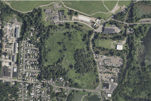
The proposed Grassy Point Bend warehouse project borders a residential neighborhood to the west, Minisceongo Creek to the east, and Rockland Green’s planned conversion of an empty warehouse into a new animal shelter to the north. The 454,000 square foot project, with 76 truck bays will operate 24/7 though no tenant has yet been secured, according to the developer. The primary driveway for trucks entering the facility will be on Ecology Lane, directly across from the planned animal shelter. The other will be on Grassy Point Road.
The 34-acre site is an uncapped construction and demolition debris landfill that was never properly closed. The grassy hill is covered with two feet of topsoil and overgrown vegetation. The project sits in the Village’s PLI (Planned Light Industrial) zone which allows for warehouse uses as-of-right, but the developer is requesting two variances.
The developer’s engineer presented a video showing the site from adjacent properties and from an aerial view.
For the past few years, the application has been winding through its environmental hurdles with the NYS DEC over how to cap the construction landfill. The land is not designated as a federal Superfund site. For the project to proceed, the agency must be satisfied the landfill can be safely capped and that controls are in place to monitor the site going forward.
In January, Terresa Bakner, a partner with Whiteman Osterman & Hanna LLP told land-use board members the New York State Department of Environmental Conservation (DEC) is “just waiting for the Village to make a decision on the applications.” She added that, “a number of Environmental Studies have been performed, as well as a Traffic Impact Study, Lighting Study, Wetland Study, and Stormwater Impact Study.”

The site, once owned by North Rockland Associates since 1969, was an active construction and demolition debris landfill through the mid-1990s. Before that the site was a clay pit quarry used when Haverstraw was a brick-making center. When the clay pit was exhausted, it became a dumping ground for construction material. In 2019, the North Rockland Associates site was transferred to a new entity, Grassy Point Bend LLC, owned by Eric Bergstol.
Bakner is representing landowner Berstol.
Berstol is collaborating with New Jersey developer Efrem Gerszberg to build the proposed $60 million to $80 million warehouse that will require an extensive environmental cleanup and continuous monitoring system.
Figueroa told the large crowd that the applicant does not yet have DEC approvals, adding “there are no assurances, no commitments.”
But Bakner, along with Frank Rossi, of Boswell Engineering of Hackensack New Jersey and Josh Herman of Stonefield Engineering made presentations at the meeting. Herman said the applicant was studying nine intersections including: Route 9W and Gurnee, Hillside, Samsondale, Railroad and Main; Railroad and Blauvelt, Samsondale and Wayne; and, Beach and Ecology.
The application raises the issue as to whether the developer’s plan to properly close and cap the landfill and build a 454,000 square-foot 76-bay warehouse is a better solution than leaving the site fallow.

The applicant has said the warehouse is a “beneficial re-use,” of the contaminated land. “It’s more viable than a vacant piece of land.”
Also, if the applicant gets DEC and RCDA (Rockland County Drainage Agency) approval, it will also need variances from the Village Zoning Board of Appeals for height (code allows for 35 feet; developer is seeking 43 feet) and parking (code requires 908 spaces based on the building size, developer says only 369 spaces are required for its use).
The RCDA is seeking assurances that the proposed development will result in no increase in the rate of stormwater runoff from the site for 100-year storm events. The Beach Road site sits adjacent to a FEMA-designated flood zone.
The developer is relying on stormwater management that includes retention ponds and a system of swales to slowly move water off site and into the Minisceongo Creek, a water body already prone to flooding.

The site sits smack at the heart of a confluence of industry, residential, and recreational facilities in the Village of West Haverstraw, and the bordering Town of Haverstraw. To the North is Railroad Avenue, which is a congested thoroughfare that filters traffic from 9W to Beach Road, along the riverfront. Rockland Green (Solid Waste Management Authority) plans to build an animal shelter in a converted warehouse on Ecology Road, across from the warehouse project’s northern border. The corridor also includes the nearby Joint Regional Sewer Authority, which emits noxious odors, and the closed Haverstraw landfill, which is used by the Haverstraw Model Aerodrome club. One resident pointed out that neighbors already suffer noise from the train, the nearby Air Metro Helicopters heliport, and heavy commercial traffic.
“We put up with the town dump, the Sewage Treatment Plant, Bowline Power Plant,” said Ed Walsh. “Why is everything down here? When the heliport was built, they said we wouldn’t hear it at night. I hear helicopters at 2 am.”
Sean Martinez said he moved up to the Village during COVID.
“I’m concerned about noise, greenhouse gases, and the aesthetics,” said Martinez. “A facility of this scope belongs near a major highway.”
Resident Helaine Nemeth made an emotional plea to the land-use boards. Concerned about contaminants that would be stirred up during the remediation and building phases, she said, “This project has the risk of causing harm because of the carcinogens. Do you want to see people get sick?”
Longtime resident Bruce Leach also implored the board to stop the project.
“We know we don’t live in a sterile environment,” he said. “We put up with the noise, trains, the airplane club. But we can’t deal with any additional truck traffic.”
Other residents asked the board to consider the project’s proximity to Peck’s Pond, the elementary school, and the impact on residents’ home property values.
The Planning Board said the next meeting will be held in mid April.